

TOWN OF NEW SCOTLAND
List of Historical Markers
Clarksville
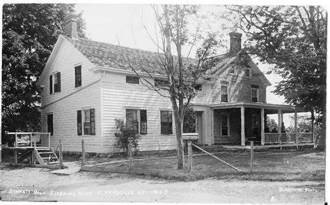
Bennett Hill House — 42°34'15.3"N / 73°57'37.9"W
House built 1821 by Wm. C. Hewitt for Wm. Chapman, 1834.
Rushmore Bennett started an apple and sheep farm.
Summer boarding house 1890’s-1920’s.
The Bennett Hill House is located near the intersection of Street A and Street B. On January 17, 1834, William and Elizabeth Chapman sold the property to Rushmore and Thomas D. Bennett (Rushmore’s younger brother) for $2,250.00. They built the framed additions on the house, soon after purchasing the property. Rushmore built a large gristmill on the Onesquethaw Creek at Clarksville. For about 3 decades, Rushmore’s daughter, Elizabeth H. Rowe ran a summer boarding house here. The "Bennett Hill House" could accommodate 40 guests, May through October, at a rate of $14.00 per week. Transportation charges from New York City to the Feura Bush West Shore Railroad Station were $4.36 and conveyance from the station to the "Bennett Hill House" was 50 cents per person and baggage was free. The carriage platform can be seen in the photo on the left. It was used for loading and unloading guests from wagons, which transported them from the railroad stations. The wrap around porch was removed several years ago.
Clark House — 42°34'32.8"N / 73°57'42.0"W
Built c. 1828 for Adam A. Clark and wife Betsy. Clarksville name in his honor Apr. 16, 1833.
First Clarksville Postmaster 1826-1841. Local innkeeper.
Houghtaling House — 42°33'52.9"N / 73°58'28.2"W
Built before 1770 by Teunis Houghtaling. Born May 18, 1740 and died May 20, 1806.
Listed on National Register June 28, 2004.
Meed House — 42°34'33.3"N / 73°57'51.0"W
Built about 1810 by Harmanus Bogardus for Henry L. Meed, first postmaster of Bethlehem P.O. from 1812-1826.
P.O. was here. Bethlehem supervisor 1821-1822.
Site of Blacksmith Shop — 42°34'32.8"N / 73°57'58.3"W
Civil War veteran John Crookes. Blacksmith here from 1864 - 1868.
Later, cooperage of Morgan F. Barber, built c. 1832 over Cave Creek. Torn down c. 1969.
Harmanus Bogardus House — 42°34'32.8"N / 73°57'58.3"W
Built by Bogardus c.1803. Adam A. Clark House 1822-1838.
John Crookes House 1864-1868. Morgan E. Barber House 1882-1918.
Burned in Great Fire of 1918.
Site of the Battle of Clarksville — 42°34'30.6"N / 73°58'24.4"W
On Dec. 3, 1838, during the Anti-Rent Wars, Sheriff Artcher and his posse marched from Albany to Clarksville. They met their first resistance here.
Feura Bush
Early Business District — 42°34'45.9"N / 73°52'30.9"W
Railroad depot c. 1870
Hallenbeck’s Store c. 1910
Hathaway’s Tavern c. 1919
Rothaupt’s Blacksmith Shop
Creble House — 42°34'42.3"N / 73°52'39.9"W
Victorian home built for Francis Creble and his wife Sara Callahan Creble in 1900-1901. Outbuildings built by 1910.
Jerusalem Reformed Church — 42°34'37.2"N / 73°52'51.6"W
Established 1791. First located on Route 308.
Rev. Harmanus Van Huysen was pastor 1793-1825. Current edifice built 1826.
Van Der Zee Manor House — 42°33'16.9"N / 73°53'18.1"W
Original house built in 1754 by Harmon Van Der Zee, grandson of Storm Bradt who was born at sea in 1636.
Slingerland-LaGrange Farm — 42°34'33.7"N / 73°55'05.0"W
Family owned 12 generations. Stone house built c. 1750s. Home of Revolutionary War soldier Albert Slingerland.
New Salem
New Salem School — 42°37'19.5"N / 73°58'10.1"W
Built in 1903, a second room was added in 1941, and the school closed in 1960.
The first New Salem school was built about 1823.
Rev. Harmanus Van Huysen House — 42°37'27.9"N / 73°56'44.2"W
Original part built c. 1816. Revolutionary War Captain served 3 area churches from 1794-1825.
His descendants lived in the home until 1922.
New Scotland
New Scotland — 42°37'52.2"N / 73°54'27.6"W
New Scotland Town formed April 25, 1832 from Bethlehem.
First town meeting held at home of Edmund Raynsford April 9, 1833.
Matthew Bullock House — 42°37'09.3"N / 73°55'32.6"W
Introduced English Short Horn cattle into Albany County about 1815 and won premiums at fairs.
Hotaling/Pound House — 42°37'43.1"N / 73°55'04.9"W
Built by Capt. Thomas Rogers c.1820. Home of Aaron Hotaling.
Owned for over 50 years by the family of Arthur Pound, state historian, poet & author.
Early Mission (Presbyterian Church) — 42°37'54.1"N / 73°54'23.4"W
Founded 1787 by Suffolk Presbytery. Incorporated 1789. 1st church 1791. Original farm standing.
Home of Bender Melons — 42°38'14.0"N / 73°54'07.8"W
Famed “Benders” developed by Charles Bender in 1900 on this New Scotland farm. Sold throughout the United States.
Coughtry Homestead — 42°39'10.3"N / 73°54'15.8"W
Family owned since 1774. This dwelling built by John McCoughtry, Jr. c. 1785.
Used as woodworking shop. Original integrity intact.
David Allen House — 42°35'36.3"N / 73°56'29.9"W
Land leased from Patroon c. 1779. Original house is stone. Wood sections added later.
Occupied by the Allen family for over 100 years.
Lime Kiln Farm — 42°35'39.9"N / 73°56'32.5"W
Named for Stone Kilns used to make lime. First farmed 1842.
Miller Family farmed here over 100 years beginning in 1905.
Henry Crounse — 42°39'10.0"N / 73°59'15.4"W
Union Army Captain, NY 91st Regiment Co. D.
Lived and farmed on this site from ca. 1822 until his death in 1901.
Indian Ladder Farms — 42°39'20.4"N / 73°58'24.7"W
Established 1916 by Peter G. Ten Eyck, Congressman and Commissioner of Agriculture, operated as a dairy and apple orchard.
Locust Vale School — 42°39'32.3"N / 73°58'60.0"W
New Scotland School District No. 11. Built about 1827 and closed 1939.
Moved to Meadowdale from Tygert Road During the 1940s.
Robert E Horton — 42°39'29.9"N / 73°54'29.3"W
Considered the father of modern hydrology lived at this location and operated a laboratory here 1920-1945.
Tory Robbery — 42°38'57.5"N / 73°58'49.0"W
Jacob Cooper Farm site nearby robbed by loyalists in June 1779.
Investigated here by Patriot Commissioners for Detecting and Defeating Conspiracies.
Onesquethaw
Onesquethaw Reformed Church — 42°33'33.6"N / 73°56'50.6"W
The Stone, builders rejected, has become the chief cornerstone. Psalm 118:22 Church built 1825 of stone rejected for the Erie Canal.
Oriskatach — 42°33'23.5"N / 73°54'37.3"W
Gerrit Van Zandt House built circa 1755 quartered as many as one hundred soldiers during the French and Indian War.
Slingerland House 1762 — 42°34'09.3"N / 73°55'23.5"W
Built by Tunis Cornelise Slingerland, Dutch emigrant 1650, on land purchased from Indians.
Van Dyke House — 42°33'14.3"N / 73°56'17.9"W
Built in 1788, by David Van Dyke a Revolutionary War veteran. The property was once part of the Rensselaerswyck Manor.
Delong-Vanderbilt Home — 42°33'33.1"N / 73°56'57.3"W
Home - June 5, 1807. Lake Creek Farm, Later Niskithaw Acres.
Built by David DeLong, father of Abiah Vanderbilt. Farmed since it was settled.
Wemp Barn — 42°33'21.1"N / 73°54'39.9"W
Mohawk Valley dutch barn built in early 1700s by Jan Wemp, Indian trader yeoman and master builder.
Thacher Park
Helderbergs — 42°39'05.5"N / 74°00'26.6"W
The name means “clear mountains.” They have been called "the key to the geology of North America."
Indian Ladder — 42°39'19.1"N / 74°01'00.3"W
In Colonial times an Indian trail ascended the Helderberg cliffs at this point from the lowlands to the east.
Tory Cave 1777 — 42°39'19.2"N / 74°01'02.5"W
Jacob Salsbury, a spy during Burgoyne Invasion, found refuge from settlers in a cave against the cliffs nearby.
Unionville
Union Dutch Reformed Church — 42°36'02.7"N / 73°53'25.5"W
Founded and erected 1825. “For the glory of God” quoted from 1824 land deed.
Horse sheds built 1840. Fellowship Hall added 1906.
Smoke House Hill Farm — 42°35'56.4"N / 73°53'54.3"W
Built Early 1800s by Peter H. Bradt. Front door from original First Jerusalem Church of 1790s era, razed 1825.
Owners maintained historic features of the house: Bradt, Heller, Paddock, Hartman, Jones, Burke, Von Ronne
Five Rivers Historic Site — 42°36'30.7"N 73°53'19.8"W
2500 BC Late Archaic Period Indian Encampment
1791 The Patroon granted 230 acres to the Ridley family
1933 New York State purchased the Radley and Ackerman farms
1933-36 Base camp for Civilian Conservation Corp. S72 - Co. 270 provided employment/housing for men who built game farm
1933-70 Delmar Experimental Game Farm propagated game birds
1941 Wildlife Research Center founded
1948-70 Delmar Zoo in operation, featuring New York’s wildlife
1972 Five Rivers Environmental Education Center opened
Voorheesville
Cider Mill — 42°39'16.0"N / 73°55'30.5"W
Empire Cider & Vinegar Co. Estab. 1890. Became Duffy Mott of Mott’s Apple Juice fame.
Employed 200 making cider, vinegar, juices. Closed 1955.
Schoolhouse No. 10 — 42°38'55.6"N / 73°56'08.1"W
Established as early as 1826. Replaced in 1867. Additions in 1892 and 1911.
Fondly known as “Brookview Academy”. Current building erected in 1929.
First Post Office 1868 — 42°39'00.8"N / 73°56'13.2"W
Established in Reid’s General Store, Farm of James Reid, Town’s first Supervisor
Grist Mill 1787 — 42°38'59.8"N / 73°55'44.4"W
Operated by Conrad Coon on Vly Creek, in early 19th century. Became carding machine for wool.
Site of Grove Hotel — 42°39'19.6"N / 73°55'41.7"W
Established by “Coon” Fryer Ca. 1874. Famed countywide.
Dances, picnics, baseball, racing. Honeymoons. Slept 50.
1886 room cost $1.50 day.
Voorhees House — 42°39'19.4"N / 73°55'47.6"W
Built by Alonzo B. Vorhees ca, 1867; elegant summer boarding house of S.V.R. & Mahula Hoes ca. 1879-1893.
Methodism — 42°39'10.7"N / 73°56'33.3"W
Here built its first church in this entire area. Known as Bethlehem, North or Black Creek Church, 1823.